Retail and civic lag
Organised retail is seven to eleven kilometres away and civic services trail the residential build-out. The campus retail corridor mitigates this for residents; the wider corridor will take longer.
Metro at Bagalur Cross, Manyata at six to eight kilometres, the airport at fifteen — and the retail and water constraints nobody should gloss over.
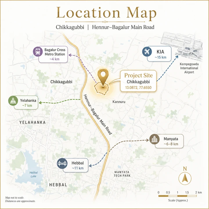
The SOBHA Hennur–Bagalur parcel sits at Byraweshwara Layout Road, Chikkagubbi Village, Bengaluru 560077 — coordinates 13.0872° N, 77.6550° E — on the Hennur–Bagalur Main Road in North-East Bangalore, between Hennur and Yelahanka and adjoining Yerappanahalli. For location reading, Sobha OneWorld keeps the context local: commute anchors, school access, hospital reach, retail convenience, and last-mile movement decide whether the address works.
It is roughly 15 to 16 km from Kempegowda International Airport, 7 km from Yelahanka, 12 km from Hebbal and 6 to 8 km from Manyata Tech Park. The Namma Metro Blue Line's Bagalur Cross station sits on the alignment nearby, targeted to open in 2027.
Hennur–Bagalur Main Road is one of two principal northern routes from the city to Kempegowda International Airport. It runs from the Hennur area north-east through Kothanur, Chikkagubbi and Kannur toward Bagalur and the airport belt beyond. The corridor's development logic is layered rather than dependent on any single driver: the airport anchors it permanently, because airports do not relocate and the land between a major international airport and a city centre appreciates structurally over decades; Manyata Tech Park and the Hebbal–Thanisandra office belt provide employment six to twelve kilometres to the south-west; Yelahanka and Jakkur supply the schools, hospitals and retail that convert a commuter corridor into a family one; and the Blue Line metro, under construction and more than half complete, adds the rail spine the corridor has always lacked. For buyers already comfortable with the sobha-limited name, Sobha Sacred Grove by the Lake adds a local portfolio lens without skipping the practical checks around cost and daily use.
| Field | Status |
|---|---|
| Corridor | KR Puram → Kempegowda International Airport |
| Length | 37 km |
| Stations | 17 |
| Relevant station | Bagalur Cross |
| Other nearby stations | Yelahanka, Jakkur Cross, Kodigehalli, Hebbal |
| Construction progress | ~52.5% complete as of September 2025 |
| Phase 2A (Silk Board – KR Puram) | Targeted late 2026, may slip to 2027 |
| Phase 2B target | December 2027 |
| Hebbal – Airport section (27.44 km) | Possibly June 2027 |
| Open to passengers, mid-2026 | No |
The full station sequence on the airport arm includes Kasturinagar, Horamavu, HRBR Layout, Kalyana Nagar, HBR Layout, Nagawara, Veerannapalya, Kempapura, Hebbal, Kodigehalli, Jakkur Cross, Yelahanka, Bagalur Cross, Bettahalasuru or Chikkajala, Doddajala, Airport City and KIAL Terminals.
This matters more than it might appear. Bengaluru residential marketing routinely invokes metro connectivity that is a decade away — the Sarjapur corridor's Phase 3A, for instance, is state-cabinet approved but had no construction tender issued as of Q1 2026 and targets completion in 2032–33. The Blue Line is different in kind. It is physically built to over half its extent and scheduled to open within roughly eighteen months. For a buyer purchasing into a project that will complete around 2030, the metro is not a speculative future benefit — it will be operating well before possession.
Historically, metro commissioning re-rates the land within walking and short-driving distance of stations. The Hennur–Bagalur corridor currently prices at ₹6,000 to ₹7,000 per sq.ft against East and South Bengaluru corridors at ₹11,000 to ₹12,500. That gap is the kind that metro connectivity typically narrows.
| Route | Detail |
|---|---|
| Hennur–Bagalur Main Road | Site frontage corridor; principal northern airport route |
| Outer Ring Road (Hebbal junction) | ~12 km |
| Bellary Road / NH-44 | Alternative airport route via Hebbal |
| Thanisandra Main Road | Connection south-west toward Manyata |
| Airport Road (via Bagalur) | Direct northern access |
Two routes to the airport is a practical advantage. When Bellary Road congests — and it does — the Hennur–Bagalur route offers an alternative that most North Bangalore corridors do not have.
| Node | Distance |
|---|---|
| Kempegowda International Airport | ~15–16 km, ~30 minutes |
| Yelahanka Junction railway station | Nearby |
| Bangalore Cantonment railway station | ~14 km |
| KSR Bengaluru City Junction | ~20 km |
The airport at 15 to 16 kilometres, on a route with a viable alternative, is the corridor's defining locational asset. For households with frequent-travel professionals, no southern or eastern Bengaluru corridor can match it.
| Destination | Distance |
|---|---|
| Manyata Tech Park | ~6–8 km |
| Karle Town Centre, Nagawara | ~9 km |
| Bhartiya City, Thanisandra | ~7 km |
| Hebbal office belt | ~12 km |
| Kirloskar Business Park, Hebbal | ~12 km |
| Embassy Manyata Business Park | ~7 km |
| RMZ Latitude, Hebbal | ~12 km |
| Aerospace Park / KIADB Hardware Park, Bagalur | ~8 km |
| Airport City / KIA employment zone | ~15 km |
Manyata is the anchor. One of Bengaluru's largest office concentrations sits six to eight kilometres away, and the Thanisandra and Hebbal clusters extend the same corridor. A resident here reaches a substantial share of North Bangalore's employment without crossing the city.
The Aerospace Park and KIADB Hardware Park at Bagalur add a second, different employment layer — manufacturing and aerospace rather than IT — which diversifies the corridor's demand base beyond a single sector. That diversification is a quieter but real strength: corridors that depend entirely on one industry's hiring cycle behave differently in a downturn from those that do not.
| Institution | Approximate distance |
|---|---|
| Legacy School, Kothanur | ~5 km |
| Vidyashilp Academy, Jakkur | ~6 km |
| Canadian International School, Yelahanka | ~7 km |
| Mallya Aditi International School, Yelahanka | ~8 km |
| Ryan International School, Hennur belt | ~7 km |
| Delhi Public School North, Sahakar Nagar | ~10 km |
| Stonehill International School, Tarahunise | ~12 km |
| Presidency School, Kasturi Nagar | ~10 km |
| New Horizon Public School, Hennur | ~7 km |
| Cambridge Public School, Bagalur belt | ~8 km |
The Yelahanka–Jakkur cluster is the strength here. Canadian International, Mallya Aditi, Vidyashilp and Stonehill are among Bengaluru's better-known institutions, all within a reasonable radius. For families, this removes the principal objection to buying in a developing corridor.
| Hospital | Approximate distance |
|---|---|
| Aster CMI Hospital, Hebbal | ~10–12 km |
| Max Hospital, Hebbal | ~10–12 km |
| Columbia Asia Hospital, Hebbal | ~11 km |
| Cytecare Cancer Hospital, Yelahanka | ~8 km |
| Manipal Hospital, Hebbal | ~11 km |
| Baptist Hospital, Hebbal | ~12 km |
| Motherhood Hospital, Hebbal | ~11 km |
| Regal Hospital, Kothanur | ~5 km |
Aster CMI and Manipal at Hebbal are the tertiary-care anchors, both around ten to twelve kilometres. Cytecare at Yelahanka is a specialist oncology centre. Day-to-day care is available closer, at Kothanur and along the Hennur corridor.
| Destination | Approximate distance |
|---|---|
| Elements Mall, Nagawara | ~9 km |
| Esteem Mall, Hebbal | ~11 km |
| RMZ Galleria, Yelahanka | ~8 km |
| Phoenix Mall of Asia, Hebbal | ~11 km |
| Bhartiya Mall of Bengaluru, Thanisandra | ~7 km |
| Neighbourhood retail, Kothanur and Hennur | ~4–6 km |
This is the honest weakness of the Hennur–Bagalur stretch. Organised retail sits at Hebbal, Nagawara, Thanisandra and Yelahanka — seven to eleven kilometres away. Along the corridor itself, retail is strip-format: functional for daily needs, limited beyond that. This is precisely what the project's planned retail corridor addresses. A dedicated retail component within a 40-acre campus would give residents daily convenience without leaving the development, and would create a retail anchor where the micro-market currently has none.
North-East Bangalore retains more open land and tree cover than the city's built-out southern and eastern corridors. Chikkagubbi and the surrounding villages still carry agricultural land and mature tree stands between developments, and the area sits at a slightly higher elevation with correspondingly better air movement than the central city. Jakkur Lake, about six kilometres away, is one of Bengaluru's better-restored water bodies. The Yelahanka lake system and the Aerospace Park green belt add further open space to the north.
Organised retail is seven to eleven kilometres away and civic services trail the residential build-out. The campus retail corridor mitigates this for residents; the wider corridor will take longer.
Much of North-East Bangalore's outer belt sits outside comprehensive BWSSB Cauvery supply and depends on borewells and tankers. Ask for source, sanctioned borewells, storage, treatment and rainwater harvesting figures.
December 2027 for Phase 2B, possibly June 2027 for the Hebbal–airport section. Both are targets. Buy on the basis that the line is 52.5% built, not that it opens on a date.
Traffic on the arterial is the fourth honest caveat. Hennur–Bagalur Main Road carries growing volume, and the stretch through Kothanur and Hennur congests at peak hours. It is materially better than Sarjapur or Whitefield, but it is not free-flowing. On airport noise: the site is 15 to 16 kilometres from the airport, far enough to sit outside the primary noise footprint, but verify against the approach path if this matters to you.
The corridor's argument is unusually legible. A permanent airport anchor. Employment at Manyata and Thanisandra within a short commute, plus a second manufacturing and aerospace layer at Bagalur. Established schooling and healthcare at Yelahanka and Hebbal. And a metro line more than half built, opening around 2027. Against that, the corridor prices at ₹6,000 to ₹7,000 per sq.ft, versus ₹11,000 to ₹12,500 on Bengaluru's eastern and southern corridors. Some of that gap reflects genuinely thinner retail and civic infrastructure. Some of it reflects the absence, until now, of rail connectivity — which is the part that changes in 2027. For a project completing around 2030, the metro will have been operating for roughly three years by possession. That is a different proposition from buying against a metro promise.
Drive the commute from the site to your workplace at 9 a.m. and 7 p.m. on a weekday, and drive to the airport on the Hennur–Bagalur route and time it yourself. Locate Bagalur Cross station relative to the site and measure the actual distance, walking or by short drive, rather than accepting a marketing description of proximity.
Ask about water — source, sanctioned borewells, storage, sewage treatment capacity, rainwater harvesting and BWSSB status — against the full sanctioned population rather than your phase. Ask what adjoins the 40 acres and what is sanctioned on the neighbouring parcels, because an open outlook today is not a permanent one. Ask about the phasing plan and which phase fronts the retail corridor. And check the approach road from the arterial to the site: its width, its surface, and how it will handle a development of this scale once occupied.
Byraweshwara Layout Road, Kanakasree Housing Society, Chikkagubbi Village, Bengaluru 560077 — at 13.0872° N, 77.6550° E. It sits on Hennur–Bagalur Main Road between Hennur and Yelahanka, adjoining Yerappanahalli and near Kannur, in North-East Bangalore.
Approximately 15 to 16 km, roughly a 30-minute drive via Hennur–Bagalur Road. The corridor also offers an alternative approach via Bellary Road, which is a practical redundancy most North Bangalore corridors lack — when one route congests, the other is available.
Yelahanka is about 7 km, Hebbal about 12 km and Manyata Tech Park about 6 to 8 km. Manyata is the corridor's principal employment anchor, with the Thanisandra and Hebbal office belt extending the same axis and the Aerospace Park and KIADB Hardware Park at Bagalur adding a second, non-IT employment layer.
Yes, and unusually for Bengaluru it is genuinely under construction. Namma Metro Blue Line Phase 2B runs 37 km from KR Puram to Kempegowda International Airport across 17 stations including Bagalur Cross, Yelahanka, Jakkur Cross, Kodigehalli and Hebbal. It was approximately 52.5% complete as of September 2025.
Phase 2B is targeted for December 2027, with the Hebbal–airport section of 27.44 km possibly opening in June 2027. Phase 2A, from Silk Board to KR Puram, targets late 2026 and may slip to 2027. Neither is open as of mid-2026. These are targets, and Bengaluru metro timelines have historically slipped — but the line being over half built is the fact that matters.
Organised retail sits 7 to 11 km away and civic infrastructure along the Hennur–Bagalur stretch trails the residential build-out. Water is a genuine constraint: much of North-East Bangalore's outer belt sits outside comprehensive BWSSB Cauvery supply and depends on borewells and tankers. The arterial also congests at peak hours through Kothanur and Hennur, though materially less than Sarjapur or Whitefield.